
Cirrus Data
Instant Terrain and Clutter
The Data Challenge
A critical component of any wireless network plan is the data that depicts a service area. But finding and working with a database that provides a realistic representation of the various regions in which networks are deployed has historically presented many challenges.
Cirrus solves the data challenge by offering instant access to custom, high-resolution data.

Instant access

Time & Money

Accurate, Complete, Current
Flexible
Instant Access
Quick Access
Get high-resolution data you need for any service area without having to spend time researching and sourcing data.
Don't Compete. Win.
Instant access improves responsiveness, giving you a competitive advantage and earning new business while retaining customers by meeting their needs immediately.
The Bottom Line
Improve your bottom line by enhancing responsiveness to RFPs and customer requests.

Time & Money
How much time do you waste converting and manipulating data?
Stop wasting time carving streets in inaccurate data that miscategorizes land use.
Stop wasting time working with incomplete data that requires you to draw in buildings and other service area features.

Spend your time on RF planning, not converting databases.
Accurate. Complete. Current.
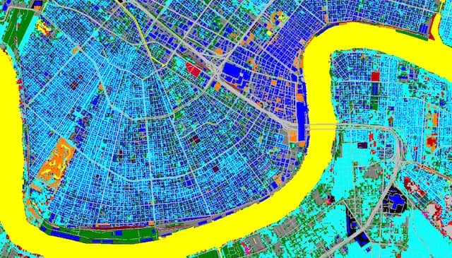
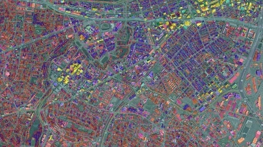
Hybrid Clutter
1m/30m Hybrid Clutter provides land use data with resolution as high as 1m, eliminating the need to manually manipulate databases.
Complete
EDX Cirrus offers all the data needed to accurately model any service area and design, deploy or optimize networks with confidence.
Current
Cirrus offers global data that is updated regularly, ensuring you have the most current information available.
Databases
- 1m/30m
- Hybrid Clutter
- 10m Terrain
- 2D Vectors
- Demographics
Flexible
Data tailored to your business and application

Global Database

US Database
Small Service Area

Cirrus Data Overview Video
Cirrus offers high-resolution data on a subscription basis for use in the design of 5G, mmWave, LTE, IoT, Smart Grid AMI, LMR and more. The data is available instantly and includes up to 1m resolution land use clutter, 10m terrain and demographics.
Cirrus Data White Paper
Learn more about the 1m/30m hybrid clutter, 10m terrain, 2D vectors and demographic data available in the Cirrus Data subscription service by reading this whitepaper. See the difference between hybrid clutter and USGS data and how this data helps improve your network.

Cirrus Data Webinar
Learn more about the Cirrus Data service as well as the return on investment in utilizing Cirrus by watching this webinar. The webinar covers:
- The advantages of high-resolution subscription data
- How to use Cirrus in SignalPro
- The business case for Cirrus
