
Effective wireless communication is a critical component in modern mining operations, especially in challenging environments such as open-pit mines situated near residential areas or in remote locations. In this comprehensive article, we explore how SignalPro can be utilized to model, analyze, and optimize wireless networks tailored for open-pit mining environments.
Understanding the Open-Pit Mining Environment
Open-pit mines present unique challenges for wireless communication due to their complex terrain and dynamic operational conditions. Unlike flat or urban environments, open-pit mines often feature significant elevation changes, deep pits, and terraced shelves that can obstruct radio signals.
For example, in one typical use case, the mine pit floor might be at an elevation of 74 meters, while the surrounding residential neighborhood sits at 101 meters or higher. This elevation difference creates natural signal blockages, especially at broadband frequencies where line-of-sight is crucial.

Moreover, the terrain in mining environments is not static. As mining progresses, the pit expands and shelves are cut or reshaped regularly, often weekly. This continuous change requires frequent updates to elevation and terrain data to maintain accurate wireless network planning.
Modeling Terrain and Elevation Data in SignalPro
Accurate terrain modeling is the foundation of successful wireless network design. SignalPro supports importing and converting various elevation data formats to build precise terrain models for your project area.
Mining operators typically generate their own elevation datasets using AutoCAD or GIS platforms. These datasets often come as DWG files showing detailed cuts and elevations of the mine. SignalPro facilitates a smooth conversion workflow:
- Export DWG files from AutoCAD into raster grid formats.
- Use SignalPro’s file conversion utility (EDXCV) to convert raster grid files into the optimized EDX format suited for Signal Propagation.
- The recommended raster format for compatibility is ESRI ArcView ASCII Grid (.ASI), widely supported by GIS and CAD software.
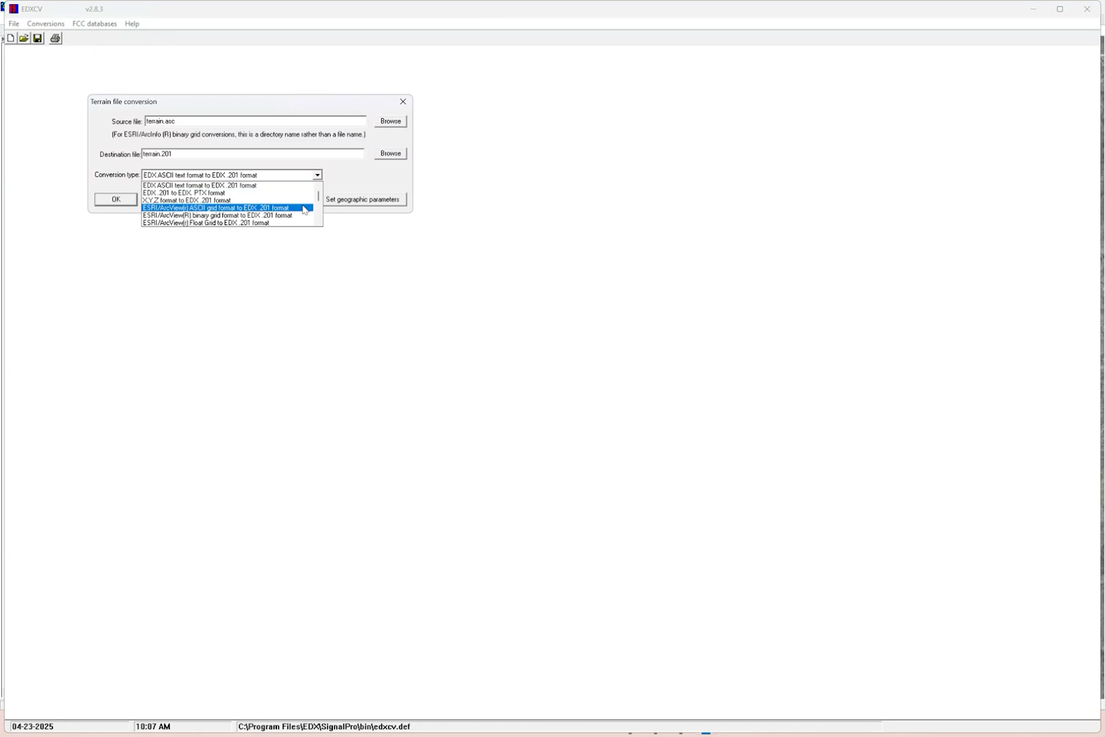
This process ensures that the complex elevation changes within the pit and surrounding areas are accurately represented, enabling precise radio propagation calculations.
To address the broader region beyond the immediate mine site, SignalPro allows layering of custom terrain data over other datasets such as the EDX Cirrus Subscription data. This means if you only have detailed elevation data for the pit but need to plan coverage over a wider operational area, SignalPro seamlessly fills in the gaps with high-resolution regional data.
Choosing the Right Wireless Technology for Mining Communications
Mining operations often rely on a portfolio of wireless technologies, ranging from legacy systems to cutting-edge broadband solutions. SignalPro supports a wide array of technologies including:
- Wi-Fi (2.4 GHz and 5 GHz bands)
- Private LTE networks
- 5G cellular technologies
- Legacy SCADA and specialized radio systems
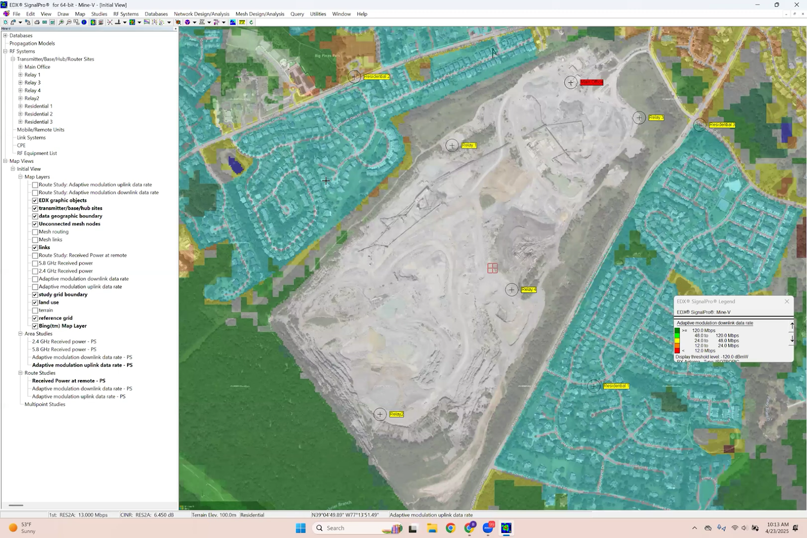
For open-pit mining, a common approach is to deploy dual-band Wi-Fi mesh networks that provide robust access and backhaul connectivity. For instance, the 2.4 GHz band often serves as the access layer connecting mobile users and devices, while the 5.8 GHz band functions as the backhaul layer linking mesh nodes and gateways.
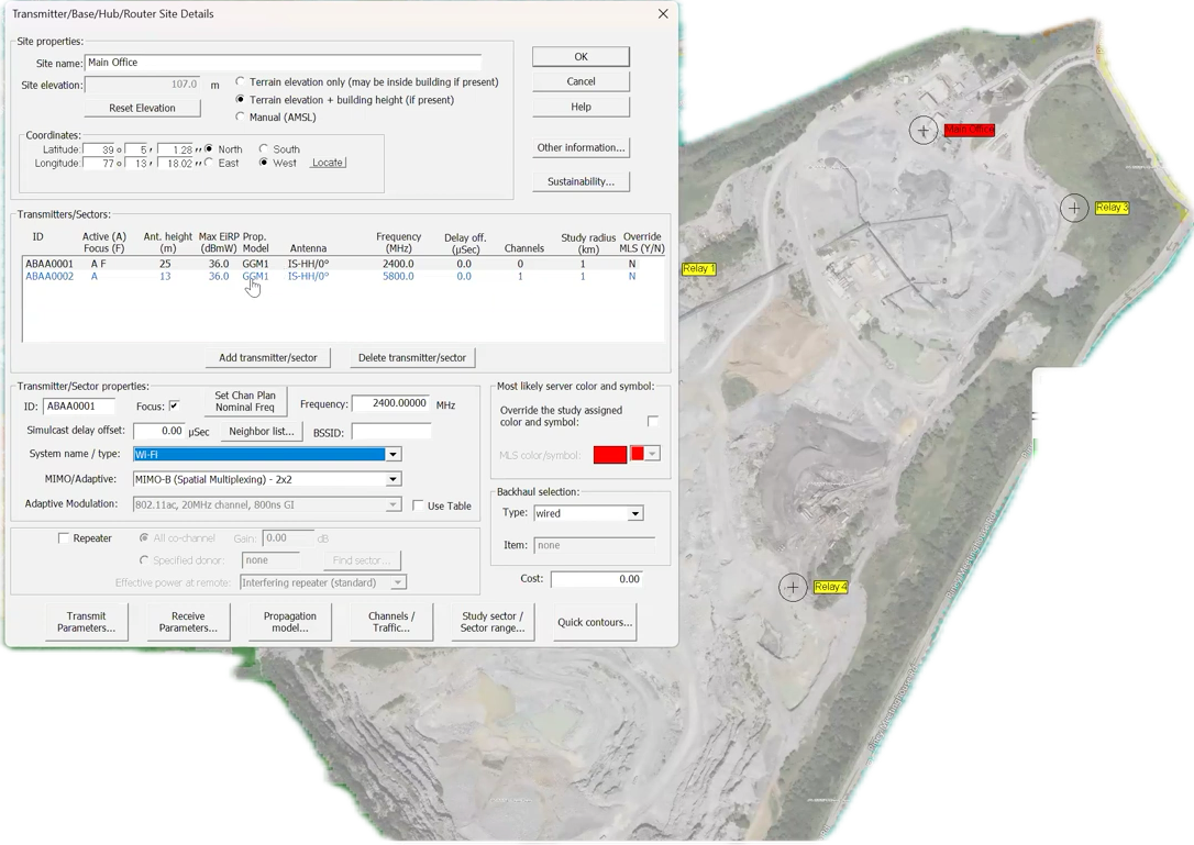
SignalPro’s Wi-Fi module allows detailed configuration of antenna types, transmit power, channel plans, and mesh topologies. This flexibility enables planners to tailor the network to the specific needs of their mining environment, whether supporting personnel, autonomous vehicles, or inspection drones.
Additionally, SignalPro’s LTE and 5G modules provide tools to evaluate the performance of these newer technologies, including bandwidth selection, frequency bands, and duplex modes. This capability is invaluable for comparing technologies and making informed deployment decisions.
Designing the Network: Site Placement and Coverage Analysis
In mining scenarios, site placement is often manual due to the flexibility of mounting antennas on trailers or mobile platforms. SignalPro supports both manual and automatic site placement:
- Manual placement: Ideal for small-scale or flexible deployments where knowledge of the terrain and operational constraints guides site selection.
- Automatic placement: Useful for larger networks with many endpoints, where SignalPro can optimize site locations based on coverage and capacity requirements.
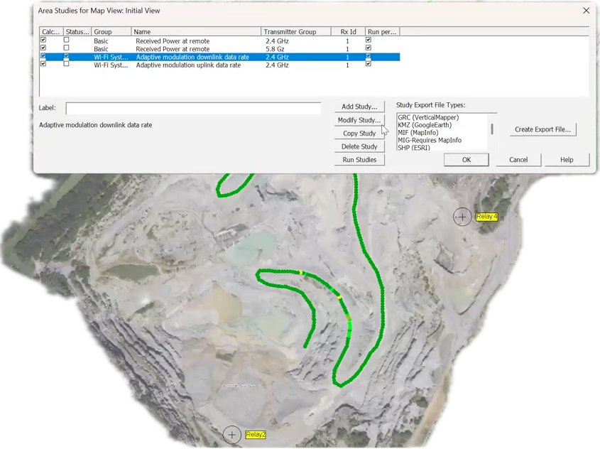
Once sites are placed, SignalPro provides powerful tools for analyzing coverage and link quality. The “Profile to Point” feature allows you to visualize the terrain profile and signal strength between any two locations, highlighting potential shadowing or marginal signal areas.
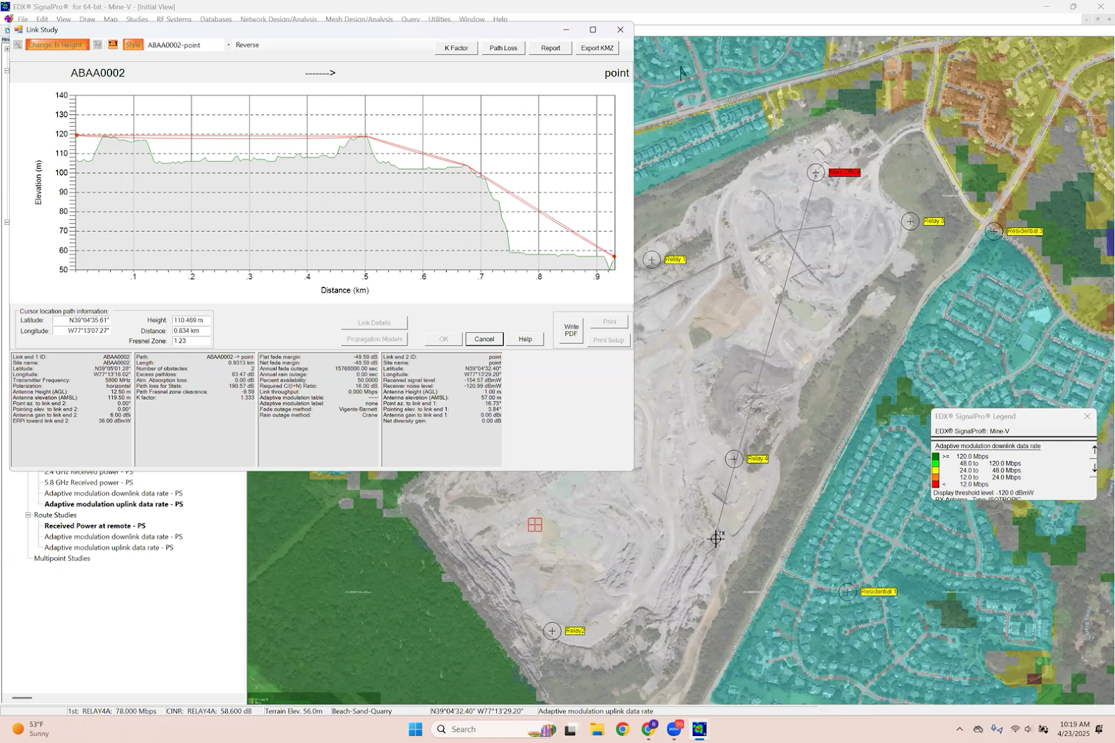
Area studies generate coverage maps showing metrics such as received power and downlink data rates across the mine and adjacent residential areas. These grids give a high-level view of network performance and help identify coverage gaps.
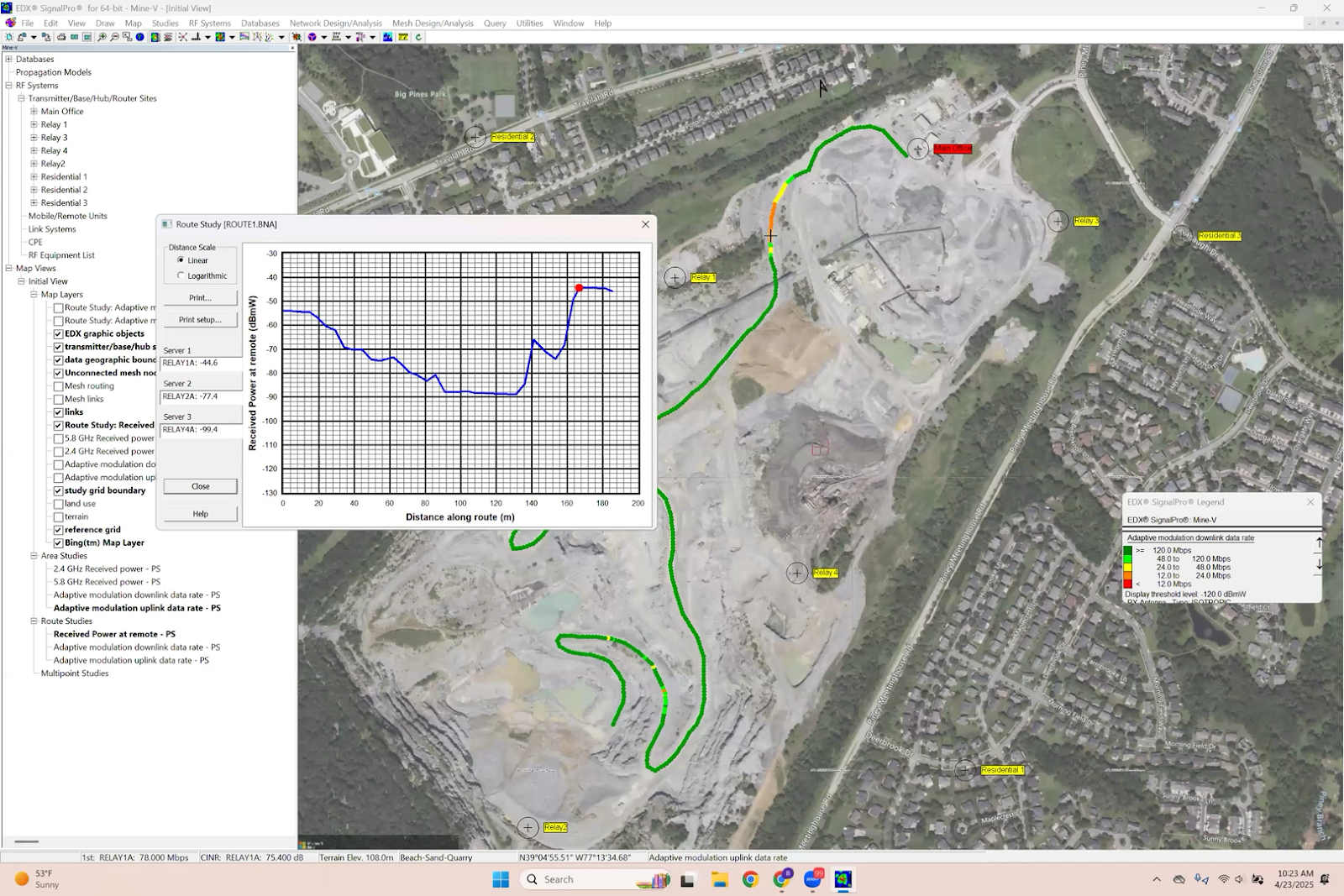
For more precise analysis, especially along critical routes such as haul roads or inspection paths, SignalPro offers route studies. These studies calculate signal metrics at closely spaced intervals (e.g., every 2 to 5 meters) along a defined path, ensuring reliable communication for vehicles or drones moving through complex terrain.
Ensuring Reliable Communications Along Vehicle and Drone Routes
Maintaining continuous connectivity to mobile assets like haul trucks or inspection drones is vital in mining operations. SignalPro’s route study capability allows planners to:
- Define exact travel paths for vehicles or drones.
- Calculate signal strength, data rates, and fading effects at fine spatial resolutions.
- Identify shadowed or marginal signal zones caused by terrain features.
- Optimize site placement or antenna parameters to mitigate coverage holes.
This level of detailed analysis is also applicable to drone flight paths, which may involve varying elevations and require seamless handoffs between sites. SignalPro supports modeling of these aerial routes to ensure inspection drones maintain high-quality video and telemetry links.
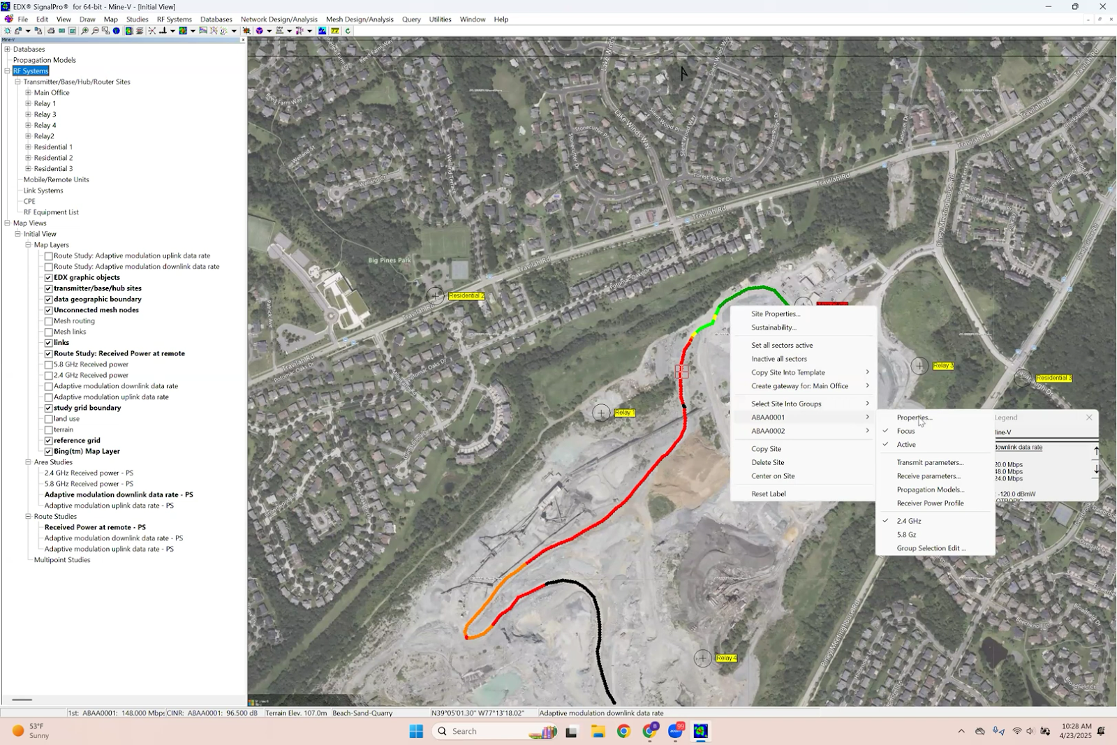
Analyzing Network Contributions with Per-Sector Studies
In complex networks with multiple sites, understanding the contribution of each individual sector or radio is crucial for efficient design and troubleshooting. SignalPro’s per-sector study feature allows you to:
- Run coverage and data rate studies for each sector individually.
- Dynamically switch the focus between sectors to visualize their unique coverage footprints.
- Determine if certain sites are redundant or if additional relays are necessary to cover shadowed zones.
For example, in a mining network, a particular relay site may cover a critical shelf area in the pit, while others may only provide limited coverage. By isolating these sectors, planners can make informed decisions about network enhancements or cost-saving site removals.
Evaluating Backhaul Options with Small-Scale Mesh Studies
Backhaul connectivity is the backbone of any wireless network, especially in mining where fiber may be impractical or too costly. SignalPro’s small-scale mesh module enables detailed analysis of mesh backhaul networks by:
- Evaluating all possible radio links between mesh nodes.
- Generating mesh routing layers to visualize multi-hop paths back to gateways.
- Assessing network resilience and identifying critical nodes whose failure would impact connectivity.
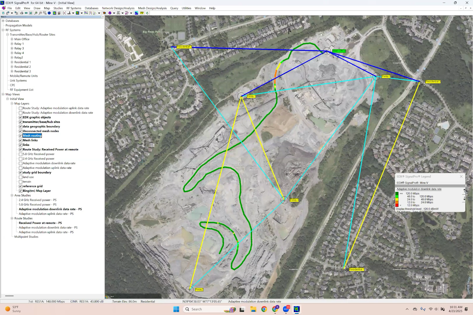
Small-Scale Mesh is especially useful for networks with up to a few hundred nodes. For larger mesh deployments, SignalPro offers the Mega Mesh module designed for scalability.
Comparing Wi-Fi, LTE, and 5G Technologies in Mining
SignalPro’s multi-technology support allows planners to compare the performance of Wi-Fi, LTE, and 5G networks within the same project environment. By configuring spectrum, channel plans, and technology profiles, you can:
- Run downlink throughput and capacity studies for each technology.
- Visualize coverage differences and data rate capabilities.
- Analyze traffic loading scenarios to predict network performance under demand.
- Make informed decisions about technology selection based on operational requirements.
This apples-to-apples comparison is invaluable for mining operators evaluating upgrades or new deployments, balancing cost, coverage, reliability, and future-proofing.
Training and Support for SignalPro Users
To maximize the benefits of SignalPro, EDX Wireless offers comprehensive support and training options:
- Self-paced online training: Learn at your own speed through step-by-step tutorials and documentation.
- Custom training sessions: Tailored webinars or workshops focusing on your specific use cases and challenges.
- Customer support portal: Access knowledge base articles, submit support tickets, and connect with technical experts.
Taming Open-Pit Mine Networks with SignalPro
Planning wireless communications for open-pit mining requires a deep examination of terrain, technology options, and operational needs. SignalPro enables engineers and planners to:
- Import and model dynamic terrain accurately.
- Compare and deploy modern wireless technologies.
- Ensure continuous connectivity for vehicles and personnel.
Whether you’re working with Wi-Fi mesh networks, keeping drones connected, or planning LTE backhaul, SignalPro helps make sense of the complex wireless landscape in mining.
With the right tools and a clear understanding of your terrain and needs, you can design a network that holds up under the demands of a changing mine site—and grows with it over time.